


Народная карта
Description of Народная карта
The Народная карта app, also known as the People's Map, is a tool designed to enhance the navigation experience within urban environments by allowing users to contribute photographs of their city or street. Available for the Android platform, this application enables individuals to share images that can assist others in finding their way around. Users can download Народная карта to start contributing to their local mapping efforts.
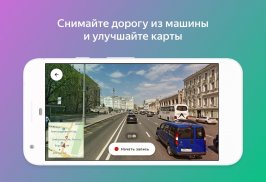
This app encourages community involvement by allowing users to take photos while walking, cycling, or driving. Each image submitted plays a crucial role in providing visual information that can help others navigate the city more effectively. For example, if a photograph reveals a road obstruction, it can inform users—particularly those with strollers or limited mobility—about potential challenges on their routes, prompting them to adjust their paths before encountering difficulties.
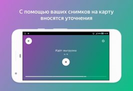
Photographs uploaded through the Народная карта app are typically between 300 to 500 KB in size. Users should be mindful that if their phone's storage is low, the ability to capture new images may be halted until space is cleared. Once photos are submitted via the app, they are automatically deleted from the user's device, allowing for efficient use of storage without the need for manual organization.
In addition to uploading images, users have the opportunity to become more actively involved in mapping their communities. By joining the community of folk cartographers, individuals can not only share photos but also contribute to editing and updating map information. This is particularly beneficial for improving the accuracy of details such as pedestrian crossings, traffic lights, and the locations of various organizations.
The app facilitates a collaborative mapping system, where contributions from numerous users can result in a more detailed and accurate representation of the city. This participatory approach ensures that the maps reflect real-time conditions and changes in the urban landscape. Users who engage with the app can feel confident that their efforts are making a tangible difference in how their community is navigated.
To participate in the mapping initiative, users simply need to download the app and start taking photos. The process of submitting images is straightforward, allowing for quick contributions that can be made during daily activities. As users capture scenes from their surroundings, they help build a collective resource that benefits everyone in the community.
The Народная карта app also emphasizes the importance of ensuring that every photograph uploaded is useful and informative. Users are encouraged to consider how the images they take can serve other individuals who may rely on the maps for guidance. This consideration promotes a sense of responsibility among users, as they recognize the impact their contributions can have on others' navigation experiences.
Moreover, the app supports various types of contributions, from scenic views to practical information about road conditions. This variety enriches the content available on the maps and provides a more comprehensive view of the urban environment. Users are motivated to explore their cities more thoroughly, as they not only capture images of their immediate surroundings but also discover new areas that may require attention.
As the community of contributors grows, so does the amount of information available on the maps. This expansion can lead to a more nuanced understanding of city layouts, helping users identify shortcuts, avoid congested areas, and locate essential services. By collaborating with fellow users, individuals can help create a resource that evolves alongside the city itself.
The app also highlights the role of technology in fostering community engagement and improving urban navigation. By utilizing smartphones to capture images and share them with others, users can bridge the gap between individual experiences and collective knowledge. The Народная карта app exemplifies how technology can empower communities to take an active role in shaping their environments.
Individuals interested in contributing to their local maps can find satisfaction in knowing that their efforts will have a lasting impact. By regularly using the app to capture and share images, users can help maintain an up-to-date reflection of their city, ensuring that it remains a reliable resource for navigation and exploration.
Through its features and community-oriented approach, the Народная карта app stands as a significant tool for enhancing urban navigation. Users can engage with their surroundings, contribute valuable information, and support fellow community members in their journeys. The app facilitates a dynamic exchange of information that ultimately enriches the urban experience for everyone involved.
For those looking to enhance their navigation skills and contribute to their community, downloading the Народная карта app offers a practical and rewarding experience. The opportunity to combine photography with mapping efforts encourages users to explore their cities while also helping others navigate effectively. The app not only serves as a mapping tool but also fosters a spirit of collaboration and community engagement that benefits all users.
For more information on joining the folk cartographer community, users can visit: https://n.maps.yandex.ru.
Народная карта - Version 15.1.0
(07-09-2024)Народная карта - APK Information
APK Version: 15.1.0Package: com.yandex.maps.mrcpublicLatest Version of Народная карта
Other versions


 4.15
4.15


Apps in the same category

You may also like...


